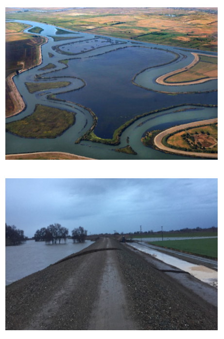
Top Photo: The San Joaquin Delta, lined with levees.
Image Courtesy of St. Mary's College of California.
Bottom Photo: Levee Breach along the San Joaquin River.
The breach resulted in the evacuation of 500 people in Manteca.
Image courtesy of the San Joaquin County Office of Emergency Services
FLOOD PROTECTION INFORMATION
Flooding in San Joaquin County
Flooding is the most common natural disaster in the United States, affecting all 50 states. Flooding typically occurs when there is a failure of water control structure, such as a levee, or when water due to rain and/or snowmelt accumulates faster than it can be absorbed or carried away by a river. San Joaquin County faces flooding risk from both of these causes.
In the early 1900s, many natural wetlands in the San Joaquin Valley were drained for agricultural use. A system of levees was introduced to prevent water from flooding the natural wetlands, which are still monitored and maintained by reclamation districts today. These districts have elected officials who patrol the levees to ensure their safety and upkeep.
In the San Joaquin Valley, there are four major rivers (the Stanislaus River, Tuolumne River, Merced River, and Mokelumne River) as well as smaller tributaries, that flow into the San Joaquin River. Melting snowpack from the Sierra Nevada as well as rainwater is carried through these rivers until they drain into the San Joaquin Delta. In a normal year, reservoirs hold the water until it can be released in a controlled manner downstream, but high precipitation can fill the reservoirs. Even on clear days, solar radiation can melt the snowpack, potentially overwhelming the reservoirs.
San Joaquin County is dedicated to reducing flooding risks and participates in the National Flood Insurance Program (NFIP) Community Rating System (CRS). This program rewards communities that take steps that go beyond minimum NFIP floodplain management requirements to reduce the risk from flooding. The County has a CRS classification of 7 which means that County residents with properties in areas with a high level of flood risk receive a 15% discount on their flood insurance premiums each year. A 5% discount applies in lower risk areas. The County encourages you to learn more about the NFIP, be aware of local risks, and be prepared to protect yourself and your property in the event of a flood, using the following resources.
Important Links
For more information on services available through the County including elevation certificates, constructing in a flood zone, and site visits, use San Joaquin County GORequest online, to submit your request. This service is accessible 24 hours a day: https://www.sjgov.org/gorequest/request
Questions regarding flood management, including Flood Protection Information, the NFIP, and CRS, can be directed to Staff at (209) 468-9596
A list of contacts and available resources regarding flood safety and protection is located HERE
Monitor current flood conditions: https://www.sjgov.org/department/oes/current-conditions
Monitor river flood forecast: http://www.cnrfc.noaa.gov/
Learn more about flood preparedness: https://www.ready.gov/floods
Learn more about flood insurance at https://www.floodsmart.gov/
Learn more about FEMA flood mapping: https://www.fema.gov/national-flood-insurance-program-flood-hazard-mapping
Learn more about flooding in California: http://cdec.water.ca.gov/